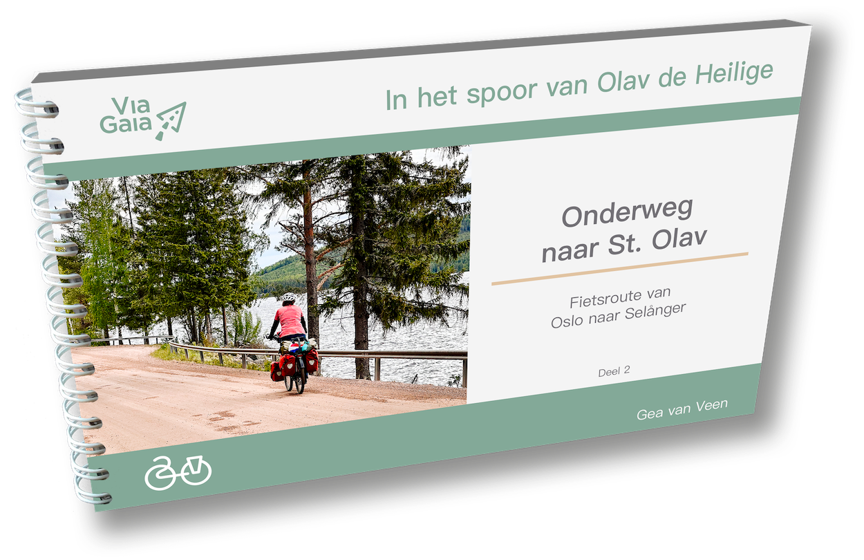
On the way to St. Olav is not a hard route to cycle over. You climb a lot, but never steep. Apart from a fer mean point, the average ascent percentage is not so high. The hard part is the distance between accommodations and supermarkets, which can get significantly large. Some planning ahead is warranted. And then some other things:
- If you like to camp in the wild, this is a great route. There are countless spots where you stay and sometimes there are lakes nearby where you can go for a swim.
- The summers may be short, but to think they are cool is a misunderstanding. Warm summers are no exception in Scandinavia. On the other hand, the weather is more temperamental than in the south of Europe.
- The route is mainly a nature route, but there's plenty to do in the cultural sense.
- Even though you cycle through woods and along lakes, the route is by no means boring!

All practical information at a glance:
The GPX track can be downloaded through the QR-code printed in the guide.
Route-segments
- 1 Norway (Oslo – Swedish/Norwegian border) – 121 km
- 2 Värmland (Swedish/Norwegian border – Uvanå) – 171 km
- 3 Dalarna (Uvanå – Dalfors) – 211 km
- 4 Gävleborg (Dalfors – Hudiksvall) – 144 km
- 5 Västernorrland (Hudiksvall – Selånger) – 124 km
Hight profile
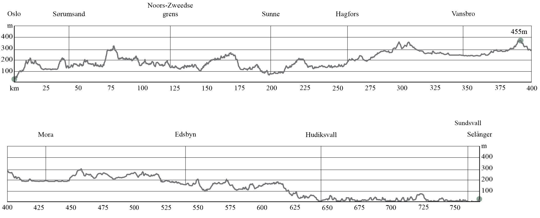
Altitude in meters
In my view these are just 'numbers' used for indication and can differ in the real world. Depending on the source or app, the elevation can differentiate up to 10%.
For those who still like numbers, here's an overview. The source here is judise.nl, a gpx-route editor which elevation numbers in Scandinavia are comparable to the popular Strava (for The Netherlands, Belgium and Nord-Rhein Westfalen the numbers of Judise are even more precise).
Segment 1, Norway
Ascent: 1170 m, descent: 1050 m
Average ascent: 2%
Segment 2, Värmland
Ascent: 1200 m, descent: 1060 m
Average ascent: 1.8%
Segment 3, Dalarna
Ascent: 1410 m, descent: 1440 m
Average ascent: 1.5%
Segment 4, Gävleborg
Ascent: 810 m, descent: 1040 m
Average ascent: 1.4%
Segment5, Västernorrland
Ascent: 760 m, descent: 740 m
Average ascent: 1.2%
And then a personal note on these numbers: I know from experience that the numbers mean very little in practice. On a distance of 600 kilometres combined with a few hundred meters ascent doesn't tell me much. What is important to me is the ascent percentage. There is a big difference between climbing with 3% over a kilometre and climbing with 18% over a kilometre. And then there is this other thing: on any one given day you feel better or worse, depending on your mood, health, weather... In short, there are many aspects that make the experience of the route hard or easy to do. No number crunching can tell you that.
End May - end September.
Keep in mind that some campsites and attractions don't open until half of June/end of June and start to close as early as half September / end of September. Sometime at the end of August. So make sure to check the appropriate website.
 Road surface quality on the bicycle route is reasonable. The larger roads tend to be of better quality. You'll both encounter asphalt and gravel road. The unpaved roads are, with one exception, easy to cycle on.
Apart from the starting and ending points, On the Way to St. Olav is a very quiet route. In the middle section, around the touristy town of Mora, you’ll encounter a bit more activity. Otherwise, only the small towns along the way bring occasional liveliness. For the most part, you’ll be cycling on quiet local roads through forests and farmland. At times, you may go for miles without seeing anyone. However, there are also roads that you’ll have to share with cars, which isn’t always pleasant. Unfortunately, there are no alternative routes without making a significant detour. Luckily, these stretches are never very long.
If you're cycling the Kristians Route, there's an optional third branch from Horten that may be interesting for those who want to continue with On the Way to St. Olav: Stage 6 Østfold.
This route is designed for those who prefer to avoid Oslo and want a shorter connection between the Kristians Route and On the Way to St. Olav.
It can also be used if you're coming from Gothenburg and planning to cycle On the Way to St. Olav.
This section is not included in the guidebook, but you can find a description of the route here: Stage Østfold.
The distances between overnight stops and supermarkets can sometimes be quite large. Some planning can be useful in such cases. At the back of the guidebook, you'll find an overview of supermarkets, campsites, and the distances between them.
Food
In larger towns, you'll find supermarkets, and occasionally, you may come across a farm shop along the way. Sometimes, there is a long distance between two shops; this is mentioned in the route description of the guidebook. In bigger towns, there are also restaurants and cafés. For a coffee or tea with a treat (Fika in Swedish), you can usually visit a hembygsgård in Sweden.
Wild Camping
Cycling with a tent has its unique advantages in Norway and Sweden. Wild camping is allowed almost everywhere in nature, as long as you maintain a distance of at least 150 meters from houses and fences. On farmland, you must ask the farmer for permission.
There are plenty of spots along the route for wild campers. The guidebook also indicates shelters (Vindskydd in Swedish) along the way. Depending on your personal standards, these shelters are often suitable for sleeping. You can also find them on the Vindskyddskartan (Shelter Map) website or the corresponding app.
Campsites
In Norway, the first campsite is only near the Swedish border, after 110 km. For many, this is too far for the first day. There is an earlier camping spot for motorhomes where you can also pitch a tent, but apart from a dry toilet, there are no sanitary facilities. This spot is at 98 km, which may still be too far for most cyclists on the first day. The remaining options are wild camping or Airbnb.
In Sweden, campsites can be found within reasonable daily distances. In addition to camping pitches, they always offer simple cabins. During peak season, it is recommended to book these in advance. In almost all cases, you will need your own sleeping bag. Most campsites also have cooking facilities where you can not only prepare meals but also eat in a dry and warm space.
Accommodation
In Oslo and the final stretch from Sundsvall, there are plenty of hotels, hostels, B&Bs, and Airbnbs. You’ll also find pilgrim accommodations, where you can usually get a discount with a pilgrim passport (available in the Via Gaia webshop or at the pilgrim centers in Oslo and Selånger).
Along the route through Norway, there are several hotels up to Lillestrøm, but after that, only Airbnbs. From the Swedish border onward, besides Airbnbs, you’ll mostly find (small) hotels and B&Bs in larger towns, with occasional options in rural areas.
If you’re a member of WarmShowers keep in mind that hosts are few and far between along this route.
A hembygdsgård is a Swedish term for a local history association or club. Often situated in a historical farm (gård). Many villages have such a small but cosy museum association or club that gathers and manages the local cultural heritage. Hembygdsgården is often used for celebrations like midsummer and Christmas, but also for weddings. In summer, there's always something to do. For cyclists, it is a perfect stop for a break. These spots are not only filled with cultural heritage, but they often serve fika, a cup of coffee with a range of homemade cake and cookies. This phenomenon is called a summer cafe. You can find such seasonal cafes on other places as well. In the - by volunteers run - hembygdsgård, the atmosphere is almost always easy-going. There are even a couple of them where you can pitch your tent for a night.
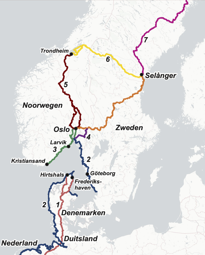
On the Way to St. Olav can be combined with the cycling routes described below. Click or tap on the route name for more information on that route.
Routes 3 to 6 are part of the series In the Trail of Olav the Saint, like On the Way to St Olav. Routes 3 and 5 connect to the starting point in Oslo, the Ruins of St Hallvards Cathedral. Route 6 connects to the finishing point in Selånger, the church ruins in Selånger.
To (or from) Oslo
- The Jutland Route/Eurovelo 3. From Emmen (NL) this route follows old trade routes in Germany and the Pilgrim route (Hærvejen – National Cycle Route 3) in Denmark.You can choose to take the ferry Fredrikshavn-Göteborg or Hirtshals-Larvik. And then cycle north to Oslo
- The North Sea Cycle Route. This route borders the whole North Sea. Parts of this route connect in Oslo.
- The Kristians route. A cycle route from Kristiansand along the southeast coast of Norway to Oslo.
- Stage Østfold. A short cut between the Kristians Route and On the Way to St Olav (part Unionsleden and part Wilderness Route).
- Gudbrandsdalsleden. A pilgrim route from Oslo to Trondheim.
From (or to) Selånger
- S:t Olavsleden. A pilgrim cycle route from Selånger to Trondheim.
- Sverigeleden. A whole cycle route network across Sweden. From Sundsvall, you can cycle north along the coast via the Sverigeleden.
The guide covers in detail how to get to Oslo or Selånger and back again, see page 101.
These are the options, plus links to the relevant booking sites:
- By train to Copenhagen, Malmö, Göteborg to Oslo.
- By train to Kiel (D) and by ferry to Oslo with Colorline or Götenborg (Stenaline).
- By train to Copenhagen (DK) and ferry to Oslo with Gotlandsbolaget. Booking goes through DFDS (this owned this route until March 2025, but still does bookings. Unfortunately, the ferry no longer goes via Frederikshavn).
- With Camino Transport. See page 101 in the guide.
- With Cycletours. See page 101 in the guide.
- Cycling along the Kristians Route from Kristiansand.
- Cycling along the Nord Sea Cycle route via Copenhagen and Götenborg.
Transport to the relevant ferry terminals
All relevant ferry ports can be reached by train. If you travel by train, you can book it via the Deutsche Bahn.

Train
In Norway, bikes can be taken on trains. However, stations can only be found along the first 45 kilometres of the route. If you want to use the train on that stretch, note the following:
The train stations along this route are, apart from Oslo Central, unmanned. You must buy a ticket online in advance. This can be done via Entur's app or Vy's app.
Buying a bike ticket does not guarantee a place for your bike. There is space on the train for a limited number of bikes.
In Sweden, bicycles are allowed on trains only on certain routes. On the cycle route En route to St. Olav, there is no possibility to board the train en route. See Info & tips for general information about taking your bike on the train in Sweden.
Bus
In Norway, your bike can also travel on the bus in many cases, provided there is room for it. The driver decides that. In Sweden, bikes cannot be taken on the bus.
N.B. if you want to use Public Transport in Sweden, check the app or Sj.se website.
Cycling alone
As far as safety is concerned, Norway and Sweden are well suited to travel alone by bicycle. 'Civilization' in the shape of roads, houses and farms are never far off, and the various villages and towns are never that far apart.
For women cycling alone, there are no additional measures needed compared to anywhere else in life. Even better, Sweden and Norway are relative safe countries for women.
There is little criminal activity, but it is still wise to lock your bicycle.
Cycling with children
In terms of heaviness and safety, this route is great for cycling with children. Although there is a lot of climbing and descending, it is never steep. For self-cycling young children, the somewhat congested roads may be slightly risky. In terms of distance, the route does have some challenges for children as there can be long distances between campsites and other accommodation.
Also in Norway and Sweden, the e-bike is gaining popularity and this route can definitely be taken with an e-bike. The same traffic rules apply to drivers of electric bicycles. However, there is one exception in Norway. There, electric bicycles are considered motorised traffic, which means that the traffic signs for motorbike traffic also apply to drivers of electric bicycles.
Tips:
- Charging will not cause any problems, as long as you don't go wild camping. However, it is useful to plan for overnight stays. If in doubt whether you can charge at your accommodation, it is useful to call in advance to ask if it is possible.
- Although the charging points have not yet been mapped, it seems to me that every village or town has a café where you can charge. Maybe it is also allowed at a petrol station, which you find a lot of, especially in Norway. By the way, those are good for everything: toilet, coffee/tea, emergency rations.... and there is almost always a bench outside.
Perhaps needless to say: always ask! People will almost always say yes, unless it's just not possible, but uninvitedly plugging in your plug somewhere is not done.